Unveiling the Vast Irrigation Project Concealed Under the Sand
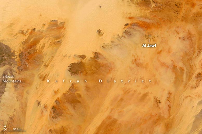
NASA's Terra satellite's Moderate Resolution Imaging Spectroradiometer captured a satellite image of the Kufrah district on May 26, 2022.
Kufrah district, located in a remote and dry area of Libya, sits atop one of the world's largest irrigation projects.
Located at the core of Sahara Desert, the remote Kufrah district in southern Libya is a landscape of sand dunes and rugged plateaus. Beneath these shifting sand dunes lies an enormous fossil aquifer and the remains of what were once rivers, now dry.
On May 26, 2022, MODIS (Moderate Resolution Imaging Spectroradiometer) on NASA's Terra satellite captured this image of Kufrah, the largest and least populated district in Libya. The Ribiana (Rabyanah) Sand Sea, a sea of unconsolidated sand, encounters the plateaus at the northern edge of the Tibesti Mountains in the upper left corner of the image.
The vegetation-free arid region features a green cluster in the top right section of the image, representing farmlands within Al Jawf city. These farming patterns reveal the irrigation methods used.
An October 22, 2016, image snapped by an astronaut on the International Space Station reveals different irrigation patterns in the farms of Al Jawf. The gridded farms in the image's upper left likely use furrow irrigation, where water is filled in evenly-spaced trenches between crop rows. Meanwhile, circular fields likely use a center pivot method, whereby water is pumped from a well at the circle's center and distributed via a long pipe that pivots around a central point.
The image below shows different irrigation patterns at the Al Jawf farms. It was taken by an astronaut aboard the International Space Station on October 22, 2016.
The irrigation system in this region uses water pumped from the substantial underground Nubian Sandstone Aquifer. The aquifer, holding fossil water that seeped into the area's sandstone from 10,000 to 1,000,000 years ago, spans much of the Kufrah district. This was a period when the region had a temperate climate and received more rainfall.
Digital elevation data from Landsat and NASA's Shuttle Radar Topography Mission (SRTM) reveal the presence of paleo-rivers that once traversed the district, a vestige of the once-wetter climate. Nowadays, the district lacks permanent rivers and lakes, receiving only about one millimeter of rain annually.
Fossil water is transported from the sandstone aquifer to populous cities on Libya's Mediterranean coast via underground pipes. This pipeline network, known as the Great Man-Made River, was built in the 1980s and 1990s to bring water from the aquifer to major cities, including Tripoli and Benghazi. The Great Man-Made River is considered one of the most extensive irrigation projects in the world, supplyin around 70% of Libya's water.
The astronaut's photograph of Al Jawf, ISS049-E-43349, was taken on October 22, 2016, using a Nikon D4 digital camera with a 1150-millimeter focal length. The Earth Science and Remote Sensing Unit at Johnson Space Center, as well as the ISS Crew Earth Observations Facility, provided the image taken by an Expedition 49 crew member. The image has been enhanced for improved contrast and has been cropped, and lens artifacts have been removed. The International Space Station Program makes images taken by astronauts and cosmonauts available on the Internet as part of the ISS National Lab initiative to help astronauts take valuable pictures of Earth for scientists and the public. The NASA/JSC Gateway to Astronaut Photography of Earth allows access to additional images captured by astronauts and cosmonauts.