Study reveals tectonic-driven rock uplift as the determining factor in Himalayan valley sizes
September 4, 2023
feature
This article has been reviewed according to Science X's editorial process and policies. Editors have highlighted the following attributes while ensuring the content's credibility:
- fact-checked
- peer-reviewed publication
- trusted source
- proofread
by Hannah Bird, Phys.org
The oceans are the final destination of weathering products from the land and its transport via rivers, with those in the Himalayan mountains alone moving one billion tons of sediment each year. To understand the storage dynamics of mountain valley systems, it is important to determine the spatial distribution of rivers, their volumes and longevity on seasonal and longer-term timescales. This is especially true given erosion processes widen valleys and therefore expand the spatial distribution of sediment influxes to oceans.
New research published in Nature Geoscience aimed to determine the controls on the changing valley shapes of the Himalayas and how this impacts sediment storage. Dr. Fiona Clubb, from Durham University, UK, and colleagues used automated software to take 1.5 million measurements across valley floors in the Himalayas to monitor width changes.
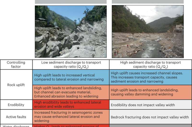
Their results indicate that river channel steepness is the dominant factor in valley floor width and is an estimate of rock uplift, with greater uplift equating to a narrower mountain valley floor. However, the timescale over which this has the most impact is on geological scales driven by tectonics, rather than the erosive action of rivers. Valley widening therefore occurs most prominently on shallow valley floors via sediment deposition, rather than lateral erosion of the surrounding bedrock.
From the thousands of measurements taken, Dr. Clubb and colleagues' results indicate that the widest valleys occur at elevations less than 1,000m, occurring in the south of the region nearing the sea, and greater than 4,000m, resulting from past glacial activity eroding the mountains.
The research team's model of two end-member states of high and low sediment transport capacity had commonality in high rates of rock uplift increasing channel slopes and therefore the velocity of river water flowing through the area. Consequently, the erosive action of the more powerful water flow would incise the underlying bedrock and so narrows the valley floor. One important caveat is that high uplift rates may also cause local instability leading to landslides that may block river channels and cause sediment deposition further upstream in the valley, thus widening it.
Bedrock composition is also a key factor investigated, particularly for the high transport capacity scenario, whereby certain rock lithologies (such as magma-derived granite and its high grade metamorphic form of gneiss, produced under extreme temperature and pressure) may be harder to erode and therefore incise to narrow the valley floor, as well as influencing the likelihood of landslides.
Areas with significant faults or prone to earthquake activity may also be susceptible to higher erosion rates and lateral widening of the valley. However, in this particular dataset there is little variation in valley width with distance from a fault, suggesting that erosion due to faults is not significant in the Himalayas for widening valleys.
Despite the expected increase in channel incision with greater water velocities in rivers from previous modeling, Dr. Clubb's team found this correlation to be weak in the Himalayan mountain range. They also found a negative correlation between water velocity and channel steepness, consistently so, no matter what the bedrock lithology was comprised of.
Furthermore, the lowest rates of rock uplift (0.1–0.2mm/year) corresponds to the widest valleys and lowest channel steepness, while high rates of exhumation over 2mm/year are matched to narrow valley floors with steep channels, which the team suggest is largely controlled by tectonic activity.
Testing elevation, channel steepness, water velocity, bedrock lithology and distance from the nearest fault in the Himalayas, channel steepness was determined to be most impactful and bedrock lithology least important. Elevation, water velocity and fault distance have similar impacts on valley floor width, with elevation only slightly ahead of the other two factors.
Therefore, high rock uplift rates (reflected by channel steepness) increase the transport capacity of rivers, with the entrained sediment eroding bedrock during peak water flows and incising to narrow the valley floor. Regions of high uplift thus fall into the low transport capacity end member of the model, while slower-uplifting regions are the high-capacity state. For the largest valleys in the Himalayan mountain range, valley fills are suggested to have residence times exceeding 100,000 years before being removed from the system.
This work also considers the effect of human influence on valley systems, such as the building of dams, which can increase valley width upstream, as well as landslides. However, the research team found that tectonic activity still had a greater influence on upstream valley widening than either of these factors.
Journal information: Nature Geoscience
© 2023 Science X Network